
The Concrete slab running between the buildings marks the line of Demarkation between the two countries. The Building on the Left is a neutral zone where talks are performed.

Can you see the North Korean up on the stairs with the Binoculars? It was kind of creepy to see him looking at us.

Neutral Zone. The left side of the table is South Korea, the Right, is North Korea.
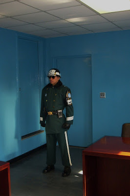
This picture was taken from the North Korean side of the room. This guy was guarding the exit to the North Korea.

I forgot what the name of this building is, but this building was built by the South Koreans with the hope that it would eventually be used for family reunions for families separated by the DMZ. But it sits empty because people arn't allowed to cross between the countries. It stands as a monument to the South Koreans desire to see unification.

This is known as Propaganda City. At least that is what the South Koreans, and the US Soldiers call it. It is the North Koreans City lying on the DMZ. It's called Propaganda City, because it sits pretty much empty. It is an attempt by the North Koreans to make it seem like they are prospering. The Flag Pole in the center of the city is the tallest Flag Pole in the World at 160 Meters. It was built so tall because the South Koreans had built a flag pole that was 100 meters, so the North Koreans wanted to appear more powerful. So thus they built this flag pole. The Flag (If I remember correctly) weighs 300 lbs. They have a crew of 40 men that have to go out and raise it everyday.

This location is the site for the Axe Murder Incident of 1976. At that time there was a tree that stood between the location where I was standing and the shack you can see in the distance. The tree had stood for years, and blocked the veiw between the two checkpoints. The US Soldiers on the base decided that it was necessary to cut the tree down to clear the view. While attempting to cut the tree down, they were attacked by North Koreans who ran accross the "Bridge of No Return." Many were killed in the resulting fight wich lasted only 20-30 seconds. The tree was eventually cut down with many more precautions taken to ensure the saftey of the "Axe-bearers."
To read the full story go to: http://en.wikipedia.org/wiki/Axe_Murder_Incident

"The Bridge of No Return." This is the bridge where North and South Korea exchanged prisoners after the Armstice. Both Sides exchanged prisoners, and never "returned" to the other side.
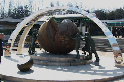
This is a monument depicting the desires of the Korean people. The two halves of the ball representing the North and South, with the Koreans on both side trying to push them back together...
Comments
I miss you!
-AG
P.S. You're right about the Korean watching you through binoculars...creepy!